5 Rice Fields to Photograph in Bali
Bali is a small island in Indonesia that has diverse landscape, from pristine beaches, sacred mountain, and eye-refreshing complex of rice field. Comprising of the majority of labour and economic of the island, rice field has an important value to grow the local economic through agriculture sector. However, the widespread rice field in Bali is also caught the attention of photographers seeking the picturesque landscapes and capture this natural beauty.
In this post, I will show you 5 rice fields in Bali (based on my personal experience) that is really beautiful to capture through your camera lens.
5 Rice Field to Photographs
Tegallalang Rice Terrace
Amongst the rice terrace in this list, Tegallalang probably the most well-known one. Located just 10 km on the north of Ubud, this destination is the must-visit place when you’re visiting Ubud. Some people already refer this as one of the Instagramable spot in Bali. With the signature curve-shaped of this rice field and the giant swing that local installed here, many people aim to get the beautiful shots in this particular destinations.
But, for landscape and aerial photographer, Tegallalang offers more than those. Having drone? it would be do your job magnificently. With the drone, you may do top-down point of view which capture the stunning layered of contour of this rice field. But it doesn’t stop there. Try to fly your drone to adjacent rice field as well. The best time to do shoot in Tegallalang is before 8 AM when the sunray passing through the slit of tress in the area, making and emphasising the shadow effect on your photograph.
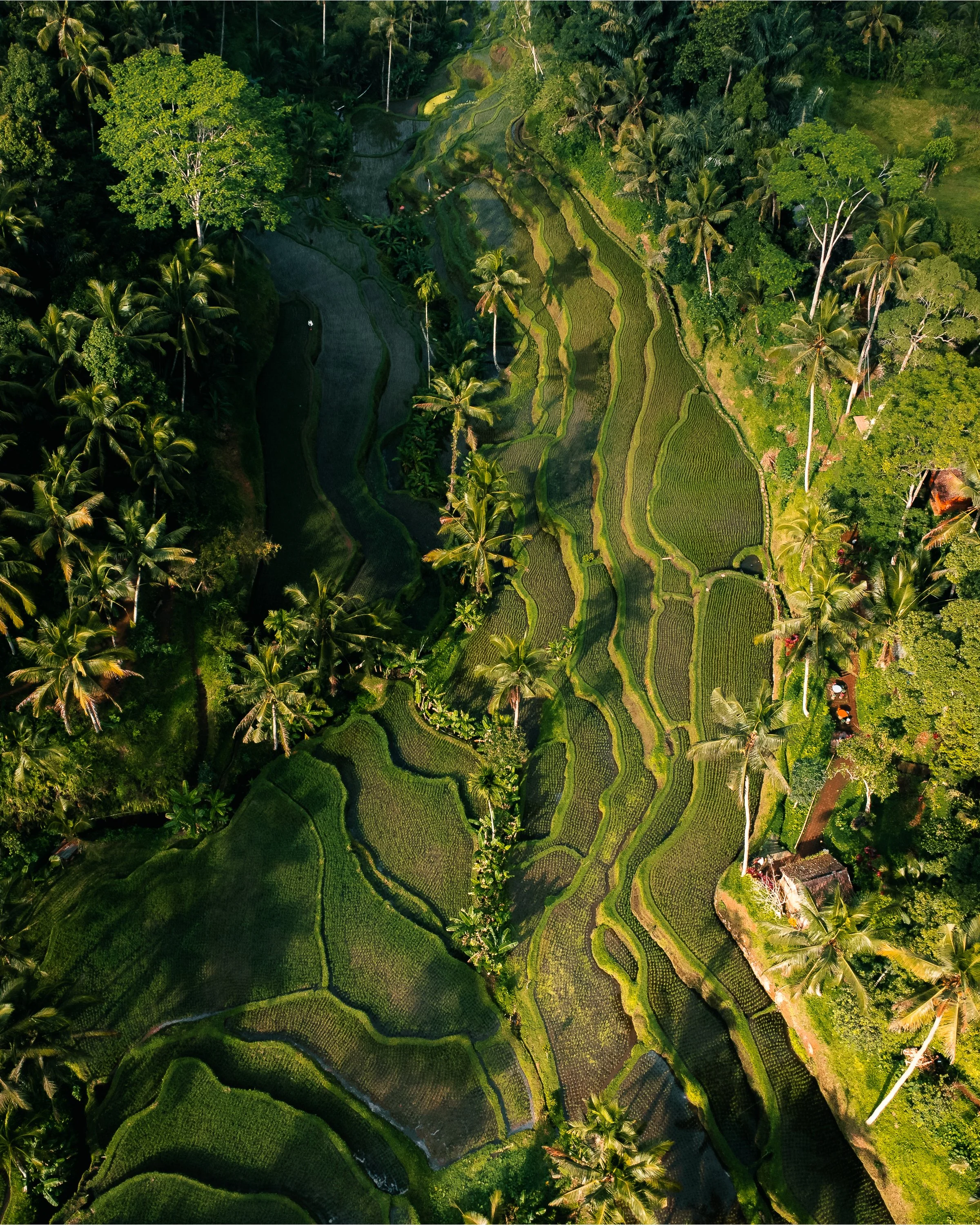

Please note that each area of rice terrace in Tegallalang have different owner. Every time you pass to another owner’s area you need to pay a fee to enter.
Jatiluwih Rice Terrace
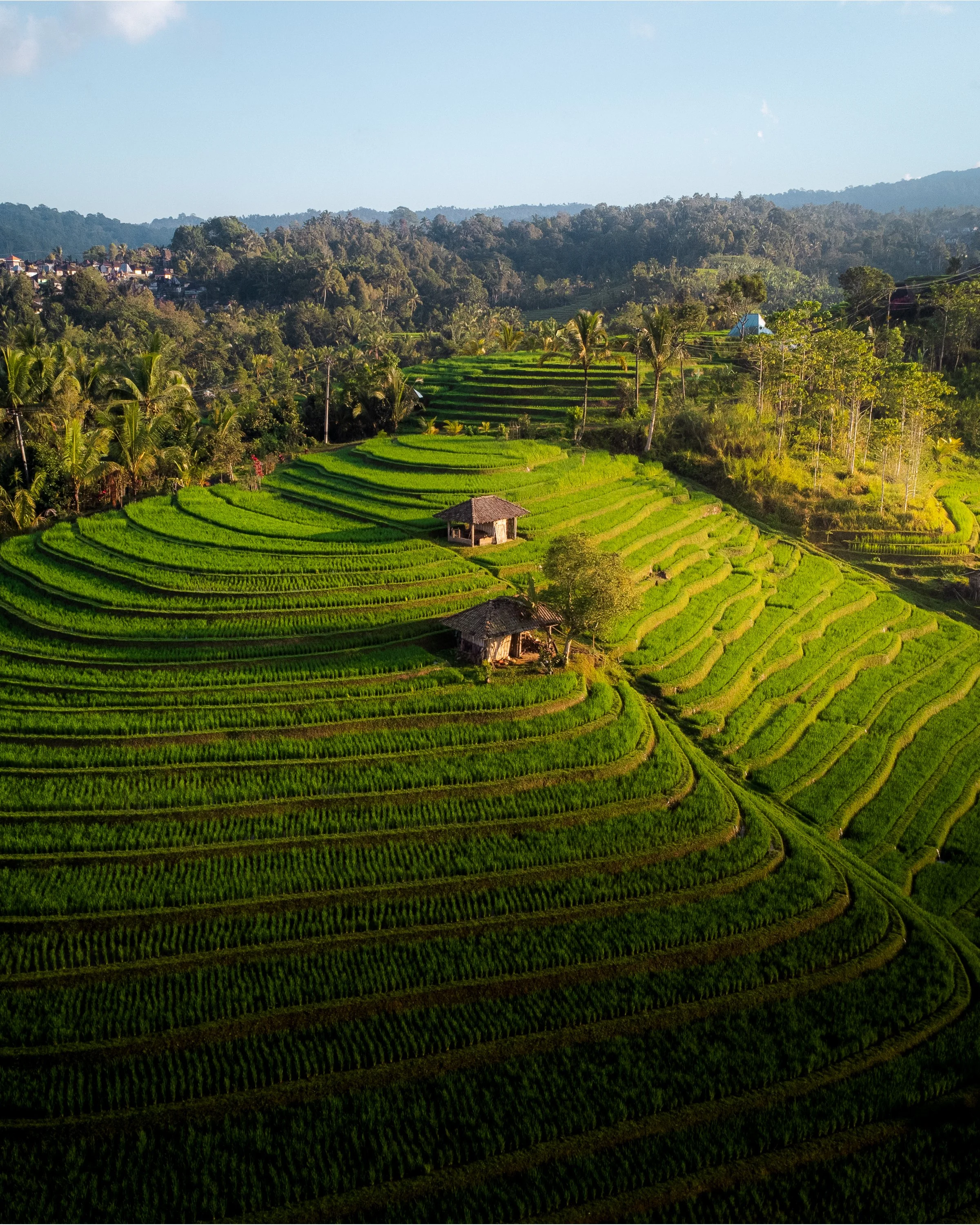
Jatiluwih Rice Terrace is a UNESCO World Heritage, well known as its extensive area of the rice field which spans over than 3,000 hectares hence makes it the largest rice terrace in Bali. Located in the heart of Bali, this rice terrace is easily accessible with 1.5 hours of motorcycle driving and adequate signpost that direct visitors to the site. Jatiluwih is also become tourism attraction among the international as well as domestic even the tourist from the Bali itself.
Even though they have proper facilities there such as cafe and accommodation, I would say this place is pretty isolated since you need to across this huge complex of rice terrace and 10 kilometres far from the main road. As icing on top, almost all merchant here only accept cash and there is no ATM facility here (the closest would be on the main road), so don’t forget to bring sufficient cash. But on a positive note, you can always wake up with the view of majestic rice field everyday.


Due to its large size, there are multiple trekking route here that you can explore. As a photographer it will give you a variety of choice of the landscape that you want to capture. Not only landscape, but also you can do street photography if capturing the human activity in rice field match to the definition. With the different altitude across the point in Jatiluwih, it offers a variety of angle that you can use on your photograph.
It would be really interesting to fly drone in Jatiluwih. However, to do this you need to pay around 10-15 USD (if i’m not mistaken based on my last visit on 2023).
Banjar Mancingan Rice Terrace
I knew this spot from locals who post the drone photo of this rice field in Instagram.
This spot is a heaven for drone photographer. Driving motorcycle for around 20-30 minutes from Ubud, you will be arrived in Banjar Mancingan Rice Terrace in Tampaksiring. Banjar Mancingan is different compared to other rice terrace because you will not (I don’t know if it’s possible or not) cross the rice field. Instead, there is a small lane, with the size of two people crossing, surrounded by coconut tree. Through this lane, you can enjoy the view of the rice field while greeting the local farmer passing around working the fields.


If you are already impressed with the eye-level view, then you need to fly your drone because that’s when the magic happens. As you fly your drone, you will see a beautiful horizon of rice field, shrouded with a thick morning mist, and shone by a morning sunrise on your screen. That’s where I really enjoy flying my drone across everywhere, piercing the mist to explore more beauty that this place offers. This moment is when I realise the urge every time I go to Bali, I need to revisit this place.
To get this moment, I advise you to fly the drone between just after sunrise time and before 8.00 AM, so you still get the morning mist and the light is not really harsh.
Tabanan Rice Terrace (Pupuan)
Tabanan is one of the regency in Bali, the second largest regency in Bali who get the epithet as Daerah Lumbung Padi or translated as rice barn area. This is due to Tabanan host the largest complex of rice field area in Bali, with more than 23,000 hectare of its land is used as rice field and farming area. The area is also include Jatiluwih Rice Terrace as it is also lays on Tabanan regency. But, with that significantly huge area of rice field, there is others rice terrace that can be explored in this regency.
Looking at the Google Earth, there are a huge area of rice field on the western part of Tabanan. I would consider this part as off-beaten track area because you will see only a few to no tourist, even the domestic one. This huge complex is located on Pupuan area, a 1,800 hectare area with the unique hilly contour and reachable by 1.5 hour motorcycle drive from Canggu.


The most well-known and probably the most established one is Belimbing Rice Field as they already build a proper facility and transportation to accommodate tourist to venture around rice field. But, if you have motorcycle and sneak around the surrounding little village there you can directly immerse yourself with extensive lush vegetation and local life throughout your journey. Wait until you fly your drone and you’ll see the extensive, almost infinite area of green rice field with the picturesque view of Sanghiang Mountain. Wherever you fly your drone in this area, you’ll encounter the rice field with different environment and contour so don’t forget to not stick in one spot as you’ll get more perspective and point of view from this rice terrace. I even come twice to fly my drone there and it is not enough because it is so massive. Fly with high altitude to highlight how massive this rice field is. Fly with low altitude to emphasise the contour, texture, and other components such as hut.
(Near) Canggu Rice Field
Over the past years, Canggu is become one of the main hotspots for tourist in Bali. This impacts to its natural aspects which depleting the rice field area significantly and revamp the function into hotels, cafes, civilisation, and other facilities to accommodate tourist.
As it’s already impossible to find natural green spaces in the heart of Canggu, we may still find it in the area between Canggu and Tanah Lot. Starting from the main road of Jl. By Pass Tanah Lot from Canggu, the roadways to several beaches like Seseh, Munggu, Nyanyi, and Mengening are surrounded by limited but still large enough rice field. Although you may not across this rice field since there is no access for public (probably), you may use your drone to photograph the rice field. The contour may not be as breathtaking as the others since the altitude difference is pretty flat. Additionally, it may be challenging to get the whole picture of the rice field itself since there is already houses or other building constructed near these areas. But, you can use the architectural structure to add more composition to your photo.


Google Maps with Satellite view or Google Earth can be your assistance to find the rice field spot around these areas.
Additional Tips
When you’re going to shoot rice field, please do consider and research about the harvesting time. Every rice field has their own harvesting season. If you’re visiting during the harvesting time, the chance you will not see the green view of the rice field. Unless you want to capture the reflective shot of the rice field, it is better avoid this period.
Personally, I like to capture rice field using drone between just after sunrise and before 7.30 or 8.00 AM. It gives sufficient light to expose the authentic hue and vibrance of the rice field. Not too dark but not too harsh.
When flying drone, it is advisable to turn on satellite mode so you can always aware if there is any interesting contour or texture within your drone range. Also use Google Maps or Earths to research the spot.
Don’t forget to fully charge your batteries and bring spares so you are able to lengthen your drone fly time.
Please remind yourself to always respect the local authorities that applied there.